


Pineapple Express to Rock Northern California for Next 8 Days
Written by Chriss W. Street

The Pineapple Express is arriving with a series of atmospheric rivers beginning on Thursday evening with light rain and followed by a week of heavy rain in the valleys and dense snow in the mountains.

Warm prevailing winds coming east from the Central Pacific tend to suck up tropical water vapor to form atmospheric rivers that that travel across the Pacific as part of the global moisture conveyor belt the West Coast. This Pineapple Express can dump up to 5inches of rain on California in one day, causing massflooding in the lower elevations and intense snowfall in higher elevations.
Northern California normally gets 70 percent of its rainfall from December to February. But the incoming storms follow November’s second-highest rainfall on record with Shasta Dam receiving 18.75 inches of rain.
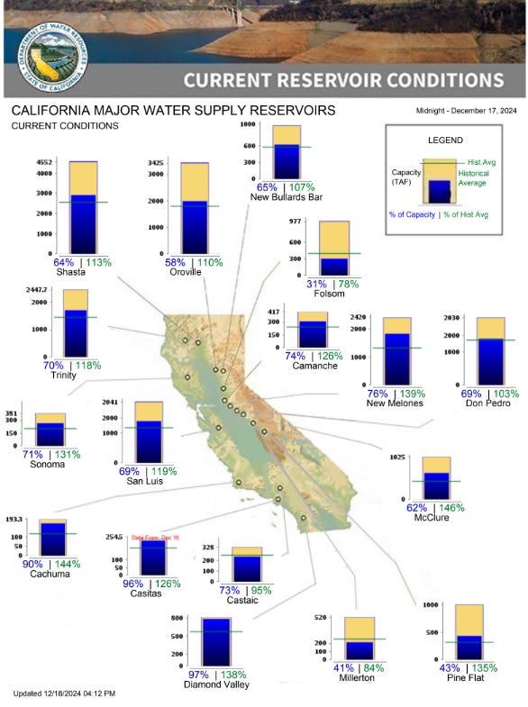
Thursday afternoon the water level at Lake Shasta, California's biggest reservoir, has gone up 6 feet since the start of December to 1,004.95 feet. At just 62 feet below the top of Shasta Dam, the reservoir pool is currently about 2/3 full at 2.94 million acre feet of water.
Shasta Dam controls the runoff from 6,665 square miles coming down the Sacramento, McCloud, and Pit Rivers, Squaw Creek rivers and from numerous minor creeks and streams. Despite the dam releasing water to travel down southat the rate of 2,042 cubic feet per second, the inflow rate is running at 12,547 cubic feet per second before the new storms hit.
The West Coast is in the process of transitioning this winter from stint of 2 years of El Niño weather conditions that are normally warm and wet, to a La Niñaweather condition that is normally dry and cold.
With most California reservoirs already running above their historical levels for this time of year, before the series of Pineapple Express arrive.
Shasta sure looks a whole lot lower than 64%. Do we trust government statistics?